The Baħrija Walk - Rambling in the Maltese Countryside
by Richard Zahra
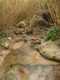 Stream where freshwater crabs live
Since I was a kid, I have delighted myself in walking through the countryside. As I grew up, I became bolder and pursued this passion abroad; in countries like Britain, France and Italy. Countryside walks allow me to relax in mind and body but also allow me to delve into my other passion – history.
Whenever I plan a holiday, one of my first priorities is obtaining walking guides of the area I intend to explore. Walking guides offer the possibility of choosing interesting and varied itineraries coupled with the chance of visiting secluded historical spots that are often difficult to find.
I was very glad when I found out that the Malta Tourism Authority had published detailed walking guides in the form of booklets. I imagined that quality tourists who travelled to Malta in search of history, culture and nature trails would find these booklets a very welcome addition to their rucksack gear.
Last winter, the well-timed advent of a public holiday, gave me the perfect excuse to test-run one of the walks, entitled ‘Baħrija Walk,’ published in October 2002. I decided to put myself in the frame of mind of a tourist who is trying to enjoy the walk.
 Site of a Bronze Age Settlement
The heavily clouded sky and strong wind did not deter me and my wife, my staunch walking companion, from embarking upon the walk. We read the booklet a couple of times to make sure we were familiar with the route.
Early in the morning, we packed our rice salad, fruit, coffee and water and drove to Rabat. We left our car close to the housing estate near the Nigret roundabout, as suggested on the booklet.
The first part of the walk was quite stressful. The road that led to Baħrija was unpaved and narrow and cars rushed past us from both directions. Not a very welcoming start to a country stride, I thought! However, the road soon took us through open country and we forgot about the cars. We walked by the gauging chamber at Fiddien, where the important Sentini water reservoir is located.
Close by, a large placard said ‘Rehabilitation project of the Qlejgħa Valley.’ We examined the area closely and discovered to our surprise, that it was supposed to be a picnic area! The overgrown vegetation had camouflaged the spot very well. The only give-away clue was the presence of a trash bin overflowing with uncollected litter. The effort and expense that had probably been put into embellishing the area with features like mesh gabions had been cancelled by lack of maintenance.
We hastily left the picnic area and followed the sign towards Baħrija. The huge Sentini reservoir to our right was the silent guardian of the lush, surrounding countryside. I realised that this reservoir collected part of the water that I drank back at home. Spring water was collected and chlorinated here and then run to Ta’ Qali reservoir in Attard. The water followed the historic route of Wignacourt’s 1615 aqueduct.
Our walk took an uphill turn. The sombre, dark-grey clouds enhanced the beauty of the fertile Ta’ Koronja Valley. It was like having an ugly painting placed beside an exquisite work of art. The ugly one looks even uglier and the nice one seems even more. Far below, we could make out the tiny bent figures of the farmers working the land. I suddenly realised that being a farmer meant seriously hard work. Public holiday or not, the land does not wait to be tilled and the seeds cannot wait to be sown!
As we plodded along, I was stunned by the quantity and variety of litter lying at the edge of the road. There was litter to satisfy the greediest of rubbish collectors – from plastic water bottles to wine jars; from food wrappers to used tissues; from broken glass to shoes and socks. Presumably, most of the litter was thrown out of car windows. I must say I felt bad imagining what tourists would think of our country as they walked by the litter. It was like blasphemy in a holy place.
Tall radio antennae signalled that we were now close to Baħrija. We saw the first red marker labelled ‘Baħrija Walk.’ We plodded along the village main road past some buildings that seemed to have been inspired by the set of Star Trek. Are there aesthetic regulations concerning the building of new dwellings in old Maltese villages? I asked myself.
We reached the Misraħ, the village square, and passed by the dilapidated miniature cottage of Little Red Riding Hood which was entirely at odds with the architecture of an old Maltese village. Across the road we gazed at what the guidebook described as a ‘…corbelled hut, underneath which there is an ancient underground rock tomb.’ A placard close by read ‘Enjoy the countryside from the road.’ I could not fail to perceive the irony of it all. The corbelled hut was flanked by untidy scrap. I could almost hear the outcry of the ancient people buried in those tombs, raging helplessly at the brazen desecration of their resting place. What would we feel if we were to know that in a few hundreds years’ time the Adolorata Cemetery would be used to dump scrap?
We walked off hastily, past the primary school. Being a science teacher myself, I imagined the great possibilities that this school had for teaching the kids to appreciate the beauty of the natural environment that cuddled their school. Hopefully, they would grow up to appreciate and respect the oasis around them.
Past the school, I saw another sign, stuck to a solitary garage. The sign said, ‘This is a place of Maltese natural beauty.’ I could not make up my mind if the situation was unbearably funny or desperately sad. Beside the garage there was the now familiar sight of a rusty car junk accompanied by a heap of scrap. The location of the sign was utterly ridiculous and I had to restrain myself from tearing it off.
We walked along a lane that took us through some farmhouses. The sight of old, humble Maltese farmhouses was such a relief! Soon we left the buildings behind. The road took a steep descent that led into the sheltered Baħrija Valley. From our lofty position we could make out the busy farmers working the land. Tall bamboo shoots, tipped with what looked like giant feathers, grew densely along the centre of the valley where a freshwater stream flows all year round.
The road gave way to a narrow cement path. We crossed the stream whose water was soothingly cool to the touch. We walked in absolute silence, trying to absorb the sounds of the valley. A freshwater crab graced us for a few moments with its presence. It was like an armoured tank, covered in its tough carapace and brandishing a pair of menacing pincers. I mused how vulnerable such a tough-looking creature was to the insensitivity of people. It is so easy for rare creatures like this one to be lost forever from our small country. Progress has turned Malta into a huge city, with only a few pockets of natural habitats left untouched.
Our eight-legged friend deftly sought the protection of its burrow as soon as it perceived us. A very wise move indeed, I thought.
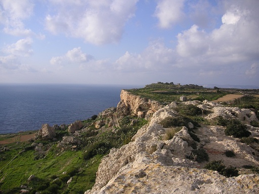
The path wound uphill to the other side of the valley. We walked to the outcrop named Il-Qlejgħa. This was the site of an important Bronze Age Settlement, described by the archaeologist D.H. Trump as ‘Malta’s most impressive Bronze Age Village.’ It is hardly impressive today. There is absolutely no clue that this was the site of a Bronze Age settlement. The guidebook somehow gave the impression that the site could be seen by taking the downhill path that led under the outcrop. However, the village site was probably on top of the plateau, which was naturally protected by cliffs. We did not venture farther than a gate that said ‘Private.’
We took the public path once more and climbed up a jutting, thyme-covered rock that enabled us to get breathtaking views of the lush, sheltered valley on one side and the roaring sea far below the cliffs on the other. From our lofty position, we got a bird’s eye view of the Qlejgħa plateau. We ate our lunches huddled together on this wind-beaten rock, the aromatic scent of thyme delighting our nostrils.
After a short rest, we took the road once more. The path now turned into pot-holed road that ran along the cliffs. We did not take the steep downhill detour suggested by the guidebook to Miġra l-Ferħa. We observed the tree-lined road winding its way steeply to the cliff edge. According to local tradition, it was at the gorge of Miġra l-Ferħa or Joyous Arrival that the Norman Count Roger landed in 1090 to take over Arab Malta with thirteen mounted knights. Most probably, the arrival of the Norman Count was not joyous at all for the local Maltese Arab population. If the legend is true, Count Roger would have been either a dumb commander or suicidal, to attempt a landing with horses at that particularly unsuitable and dangerous landing place.
As we walked past an old building that, according to the guidebook, served as a lookout post for shoals of fish and a store room up to the early twentieth century, the landscape took on a new form. The pitted rocks told us that this was the typical Maltese garigue known locally as xagħri. The hardy vegetation grew in pockets of soil that were trapped in the rock cavities.
We passed by old Roman quarries. These were conspicuously unmarked except by a painted sign warning sightseers that this was private property. I had often walked by these quarrie, but never had any clue as to what they really were, until I read the guidebook.
As we trod along, the hamlet of Mtaħleb came into view. It was perched precariously on the edge of a cliff. Beneath it was a lush, intensely cultivated valley that had a copious supply of spring water for irrigation. Caves in the cliff face were still used by farmers as storage space or to keep livestock. It seemed that here, the intense relationship between man and the land was still throbbing with life.
This hamlet had been the estate of a noble family that resided at Mdina, Malta’s oldest capital. The weather-worn family emblem stood on top of the portal that denied access to the private road leading to the hamlet.
The most imposing building was the Mtaħleb chapel, built in 1656 and dedicated to the Nativity of our Lady. It stood out amongst the farmers’ dwellings like a finely clad nobleman amidst more modestly clothed peasants.
We then walked past a building where substance abuse therapy is provided and took the road downhill. In the background I could see Mdina, Dingli and the dome of the radar station at Dingli cliffs. On the way I stopped to ask a farmer if there was a road that led to Dingli. He told me that I would soon find a crossroads with one of the branches marked Dingli. I bade him good day and we walked on.
When we reached the crossroads we were tempted to take a detour to Dingli Cliffs but then decided to follow the original route suggested by the guidebook. The wind was getting stronger but though the sky was overcast, not a drop of rain fell. We walked astride Wied il-Bużbież (Fennel Valley) past a row of imposing eucalyptus trees. A small dog raced across a field to greet us as we passed by.
Soon we found ourselves on the road that we had come from and we plodded hastily uphill towards Rabat, intent on avoiding the speeding cars that rushed past us. After four and a half hours of marching, we were back to the starting point.
Although somewhat marred by unsightly trash, the walk proved a relaxing and enjoyable experience. The walk would have been more enjoyable if we started at Baħrija thus avoiding the busy road between Rabat and Fiddien.
We noted a pronounced lack of both local and foreign ramblers. In fact I can affirm that we did not meet a single living soul walking. Maybe the threat of impending rain scared people off. Winter is a great time to walk through the Maltese countryside as the rain provides much needed water to make life bloom and flourish and the temperatures are cool enough to make walking comfortable. However if you want to enjoy the walk, you should wear waterproof walking shoes and an impermeable jacket.
And by the way, don’t forget to buy a guidebook. You will be surprised how many interesting places you can miss out or overlook if you wander around aimlessly. A little reading before the walk is certainly worth the effort. So go out and enjoy the countryside!
Early in the morning, we packed our rice salad, fruit, coffee and water and drove to Rabat. We left our car close to the housing estate near the Nigret roundabout, as suggested on the booklet.
The first part of the walk was quite stressful. The road that led to Baħrija was unpaved and narrow and cars rushed past us from both directions. Not a very welcoming start to a country stride, I thought! However, the road soon took us through open country and we forgot about the cars. We walked by the gauging chamber at Fiddien, where the important Sentini water reservoir is located.
Close by, a large placard said ‘Rehabilitation project of the Qlejgħa Valley.’ We examined the area closely and discovered to our surprise, that it was supposed to be a picnic area! The overgrown vegetation had camouflaged the spot very well. The only give-away clue was the presence of a trash bin overflowing with uncollected litter. The effort and expense that had probably been put into embellishing the area with features like mesh gabions had been cancelled by lack of maintenance.
We hastily left the picnic area and followed the sign towards Baħrija. The huge Sentini reservoir to our right was the silent guardian of the lush, surrounding countryside. I realised that this reservoir collected part of the water that I drank back at home. Spring water was collected and chlorinated here and then run to Ta’ Qali reservoir in Attard. The water followed the historic route of Wignacourt’s 1615 aqueduct.
Our walk took an uphill turn. The sombre, dark-grey clouds enhanced the beauty of the fertile Ta’ Koronja Valley. It was like having an ugly painting placed beside an exquisite work of art. The ugly one looks even uglier and the nice one seems even more. Far below, we could make out the tiny bent figures of the farmers working the land. I suddenly realised that being a farmer meant seriously hard work. Public holiday or not, the land does not wait to be tilled and the seeds cannot wait to be sown!
As we plodded along, I was stunned by the quantity and variety of litter lying at the edge of the road. There was litter to satisfy the greediest of rubbish collectors – from plastic water bottles to wine jars; from food wrappers to used tissues; from broken glass to shoes and socks. Presumably, most of the litter was thrown out of car windows. I must say I felt bad imagining what tourists would think of our country as they walked by the litter. It was like blasphemy in a holy place.
Tall radio antennae signalled that we were now close to Baħrija. We saw the first red marker labelled ‘Baħrija Walk.’ We plodded along the village main road past some buildings that seemed to have been inspired by the set of Star Trek. Are there aesthetic regulations concerning the building of new dwellings in old Maltese villages? I asked myself.
We reached the Misraħ, the village square, and passed by the dilapidated miniature cottage of Little Red Riding Hood which was entirely at odds with the architecture of an old Maltese village. Across the road we gazed at what the guidebook described as a ‘…corbelled hut, underneath which there is an ancient underground rock tomb.’ A placard close by read ‘Enjoy the countryside from the road.’ I could not fail to perceive the irony of it all. The corbelled hut was flanked by untidy scrap. I could almost hear the outcry of the ancient people buried in those tombs, raging helplessly at the brazen desecration of their resting place. What would we feel if we were to know that in a few hundreds years’ time the Adolorata Cemetery would be used to dump scrap?
We walked off hastily, past the primary school. Being a science teacher myself, I imagined the great possibilities that this school had for teaching the kids to appreciate the beauty of the natural environment that cuddled their school. Hopefully, they would grow up to appreciate and respect the oasis around them.
Past the school, I saw another sign, stuck to a solitary garage. The sign said, ‘This is a place of Maltese natural beauty.’ I could not make up my mind if the situation was unbearably funny or desperately sad. Beside the garage there was the now familiar sight of a rusty car junk accompanied by a heap of scrap. The location of the sign was utterly ridiculous and I had to restrain myself from tearing it off.
We walked along a lane that took us through some farmhouses. The sight of old, humble Maltese farmhouses was such a relief! Soon we left the buildings behind. The road took a steep descent that led into the sheltered Baħrija Valley. From our lofty position we could make out the busy farmers working the land. Tall bamboo shoots, tipped with what looked like giant feathers, grew densely along the centre of the valley where a freshwater stream flows all year round.
The road gave way to a narrow cement path. We crossed the stream whose water was soothingly cool to the touch. We walked in absolute silence, trying to absorb the sounds of the valley. A freshwater crab graced us for a few moments with its presence. It was like an armoured tank, covered in its tough carapace and brandishing a pair of menacing pincers. I mused how vulnerable such a tough-looking creature was to the insensitivity of people. It is so easy for rare creatures like this one to be lost forever from our small country. Progress has turned Malta into a huge city, with only a few pockets of natural habitats left untouched.
Our eight-legged friend deftly sought the protection of its burrow as soon as it perceived us. A very wise move indeed, I thought.
The path wound uphill to the other side of the valley. We walked to the outcrop named Il-Qlejgħa. This was the site of an important Bronze Age Settlement, described by the archaeologist D.H. Trump as ‘Malta’s most impressive Bronze Age Village.’ It is hardly impressive today. There is absolutely no clue that this was the site of a Bronze Age settlement. The guidebook somehow gave the impression that the site could be seen by taking the downhill path that led under the outcrop. However, the village site was probably on top of the plateau, which was naturally protected by cliffs. We did not venture farther than a gate that said ‘Private.’
We took the public path once more and climbed up a jutting, thyme-covered rock that enabled us to get breathtaking views of the lush, sheltered valley on one side and the roaring sea far below the cliffs on the other. From our lofty position, we got a bird’s eye view of the Qlejgħa plateau. We ate our lunches huddled together on this wind-beaten rock, the aromatic scent of thyme delighting our nostrils.
After a short rest, we took the road once more. The path now turned into pot-holed road that ran along the cliffs. We did not take the steep downhill detour suggested by the guidebook to Miġra l-Ferħa. We observed the tree-lined road winding its way steeply to the cliff edge. According to local tradition, it was at the gorge of Miġra l-Ferħa or Joyous Arrival that the Norman Count Roger landed in 1090 to take over Arab Malta with thirteen mounted knights. Most probably, the arrival of the Norman Count was not joyous at all for the local Maltese Arab population. If the legend is true, Count Roger would have been either a dumb commander or suicidal, to attempt a landing with horses at that particularly unsuitable and dangerous landing place.
As we walked past an old building that, according to the guidebook, served as a lookout post for shoals of fish and a store room up to the early twentieth century, the landscape took on a new form. The pitted rocks told us that this was the typical Maltese garigue known locally as xagħri. The hardy vegetation grew in pockets of soil that were trapped in the rock cavities.
We passed by old Roman quarries. These were conspicuously unmarked except by a painted sign warning sightseers that this was private property. I had often walked by these quarrie, but never had any clue as to what they really were, until I read the guidebook.
As we trod along, the hamlet of Mtaħleb came into view. It was perched precariously on the edge of a cliff. Beneath it was a lush, intensely cultivated valley that had a copious supply of spring water for irrigation. Caves in the cliff face were still used by farmers as storage space or to keep livestock. It seemed that here, the intense relationship between man and the land was still throbbing with life.
This hamlet had been the estate of a noble family that resided at Mdina, Malta’s oldest capital. The weather-worn family emblem stood on top of the portal that denied access to the private road leading to the hamlet.
The most imposing building was the Mtaħleb chapel, built in 1656 and dedicated to the Nativity of our Lady. It stood out amongst the farmers’ dwellings like a finely clad nobleman amidst more modestly clothed peasants.
We then walked past a building where substance abuse therapy is provided and took the road downhill. In the background I could see Mdina, Dingli and the dome of the radar station at Dingli cliffs. On the way I stopped to ask a farmer if there was a road that led to Dingli. He told me that I would soon find a crossroads with one of the branches marked Dingli. I bade him good day and we walked on.
When we reached the crossroads we were tempted to take a detour to Dingli Cliffs but then decided to follow the original route suggested by the guidebook. The wind was getting stronger but though the sky was overcast, not a drop of rain fell. We walked astride Wied il-Bużbież (Fennel Valley) past a row of imposing eucalyptus trees. A small dog raced across a field to greet us as we passed by.
Soon we found ourselves on the road that we had come from and we plodded hastily uphill towards Rabat, intent on avoiding the speeding cars that rushed past us. After four and a half hours of marching, we were back to the starting point.
Although somewhat marred by unsightly trash, the walk proved a relaxing and enjoyable experience. The walk would have been more enjoyable if we started at Baħrija thus avoiding the busy road between Rabat and Fiddien.
We noted a pronounced lack of both local and foreign ramblers. In fact I can affirm that we did not meet a single living soul walking. Maybe the threat of impending rain scared people off. Winter is a great time to walk through the Maltese countryside as the rain provides much needed water to make life bloom and flourish and the temperatures are cool enough to make walking comfortable. However if you want to enjoy the walk, you should wear waterproof walking shoes and an impermeable jacket.
And by the way, don’t forget to buy a guidebook. You will be surprised how many interesting places you can miss out or overlook if you wander around aimlessly. A little reading before the walk is certainly worth the effort. So go out and enjoy the countryside!
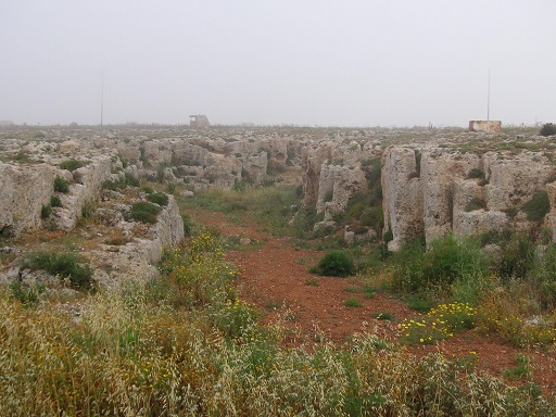
Roman Quarry
|
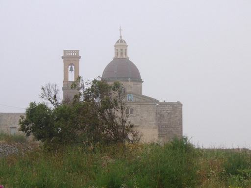
Mtahleb Chapel
|
